Free Shipping Over $150 *exclusions may apply
Reduces native 220V electric current to 110V • For use in EU countries, and all countries operating on 220V • Low (LO) switch setting for low watta...
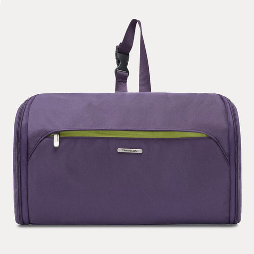
View full detailsWith Multiple Compartments Keep your personal items neatly organized and easily accessible with the Flat-Out Hanging Toiletry Bag. Unlike single-co...
View full detailsAdvanced Series Travel without limits equipped with our advanced series World Travel Essentials (WTE), gear that solves packing problems. Our premi...
View full detailsUsing TRAVELON Compression Packing Bags will change the way you pack forever. Remove excess air from bulky garments to save up to 80% of your packi...
View full detailsWhy bother with a bulky and heavy adapter kit? The Travelon Worldwide Adapter and USB Charger is a compact cube that weighs less than 5 ounces and ...
View full detailsInternationally compatible with over 150 countries Why bother with a bulky and heavy adapter kit? The Travelon Universal Adapter is a compact cube ...
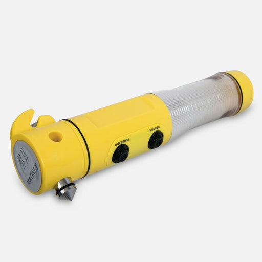
View full detailsAuto Car Safety Escape Hammer Seat Belt Cutter Flashing Beacon and LED Flashlight Be well-prepared for nearly any automotive emergency with the Tra...
View full detailsOur innovative contour eliminates head drop and the instinctive "whiplash" response to reopen obstructed airways. Raised side supports prevent late...
View full detailsLock your bag worry free with this TSA Accepted Luggage Lock. TSA agents have coded passkeys so they are able to open the lock and inspect the bag ...
View full detailsThis durable strap adjusts to fit virtually any size suitcase. The bright pattern assures your bag will be easily seen among the sea of black suitc...
View full detailsThe Set of 2 Smart Tubes, are perfect for creating and transporting travel-size quantities of personal care products, beverages, and condiments. Si...
View full detailsThe Set of 2 Smart Tubes, are perfect for creating and transporting travel size quantities of personal care products, beverages, and condiments. Si...
View full detailsSay goodbye to tangled cords. Want to finally feel more organized? That's EXACTLY why we made this travel cord and tech accessory organizer. It's t...
View full detailsDon't fear a disorganized bag again! The Packing Organizers offer 3 sizes for organized packing without excess weight. Zippers offer easy access to...
View full detailsTravel without limits when you are equipped with our advanced packing series – World Travel Essentials. Serious tools for serious solutions to pack...
View full detailsThe Travelling Light RFID Travel Wallet is a lightweight, strong, water-resistant, and convenient way to keep all of your essential travel document...
View full detailsCarry two bags as one. Carry more with less effort with the Bag Bungee. The Bag Bungee attaches easily to handle system of wheeled luggage, includi...
View full detailsReusable ear plugs with an easy grip and cushion tip for added comfort. Ear plugs help to reduce loud volumes while preserving sound quality. These...
View full detailsAlthough airplane cabins are pressurized to minimize the effects of rapid air pressure changes during flight, many passengers still experience pai...
View full detailsCompact And Sturdy The Travel Clothes Line makes it easy to rinse out a bathing suit after a swim or other items as needed with a simple drip-dry s...
View full detailsALL MAPS FINAL SALE - A medium-scale (1:40,000) paper map of Kawartha Highlands Provincial Park that can be helpful when planning your trip. It sho...
View full detailsALL MAPS FINAL SALE - A wilderness conservation area between the towns of Ancaster and Dundas, this area is popular with hikers, mountain bikers, a...
View full detailsALL MAPS FINAL SALE - This 3rd guide in our Missinabi series covers the route from the Town of Mattice all the way downstream or northward to Mooso...
View full detailsALL MAPS FINAL SALE - Looking for a huge expanse of world-class wilderness paddling territory? Then Woodland Caribou Provincial Park in northwester...
View full details