Free Shipping Over $150 *exclusions may apply
ALL MAPS ARE FINAL SALE Scale: 1:60,000. Waterproof. This map shows the southwestern side of classic Temagami, an area of relatively easy access by...
View full detailsAll maps are FINAL SALE Scale: 1:20,000. Waterproof. To most people Wasaga Beach means kilometres of white sandy beach on the shore of Georgian Bay...
View full detailsAll maps are FINAL SALE Scale: 1:80,000. Waterproof. One of the world's great paddling areas, Temagami provides thousands of lakes and rivers among...
View full detailsAll Maps are FINAL SALE Scale: 1:60,000. Waterproof. One of southern Canada's great wilderness rivers - the Spanish - is located northwest of Sudbu...
View full detailsThe physical copy of the Reference Guide includes: All 42 detailed maps of the Bruce Trail A handy six ring binder that allows you to take a map ...
View full detailsA large, medium-scale (1:42,000) waterproof map of the entirety of Sleeping Giant Provincial Park and surroundings that is perfect for planning you...
View full detailsALL MAPS FINAL SALE - The eastern Lake Superior coast offers wonderfully rugged wilderness hiking and backpacking as well as coastline and backcoun...
View full detailsALL MAPS FINAL SALE - Most serious paddlers have heard of the Missinaibi River - the longest unbroken stretch of paddling river in Ontario - but th...
View full detailsALL MAPS FINAL SALE - This map is the heart of Temagami - the octopus-like lake that has become one of Ontario's more popular tourist destinations....
View full detailsEscaping into nature is more important than ever, and what better way to do it than with a Loops & Lattes hiking guide tucked under your arm? W...
View full detailsOne Trail, Two Views Most maps only show the trail from a bird's-eye view. That gives a great overview of how things fit together, but not what yo...
View full detailsOne Trail, Two Views Most maps only show the trail from a bird's-eye view. That gives a great overview of how things fit together, but not what yo...
View full detailsContains West Montreal River, Makobe-Grays River and Crown Land FINAL SALE
Contains Lady Evelyn-Smoothwater, Solace & Crown Land FINAL SALE
Contains Marten River Provincial Park & Crown Land FINAL SALE
Contains Maple Mtn. & Crown Land (Lake Temagami, Obabika & More) FINAL SALE
Contains Chiniguchi, Sturgeon River, Temagami River & Crown Land. FINAL SALE
Contains Crown Land (South River & More) FINAL SALE
ALL AMPS FINAL SALE Scale: 1:125,000. Waterproof. Quetico Provincial Park, located in northwestern Ontario on the international border with Boundar...
View full detailsAn Illustrated Field Journal for Newfoundland’s East Coast Trail (ECT Journal) features whimsical maps of 20 of the East Coast Trail’s 25 paths whi...
View full detailsALL MAPS ARE FINAL SALE This waterproof edition of the French River Provincial Park can be used both at home as a general reference map for preplan...
View full detailsContains Restoule Provincial Park & Crown Land FINAL SALE
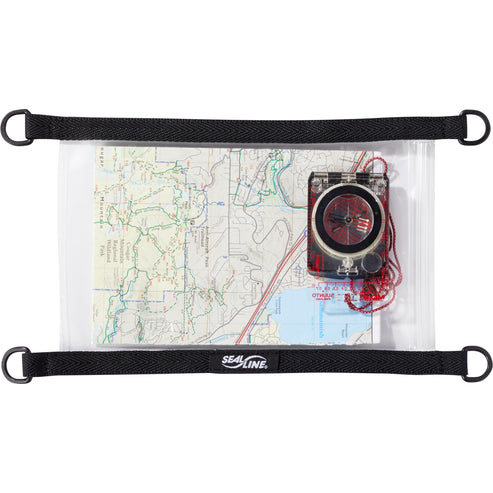
For any adventure where the elements could be an issue, our waterproof Map Case is the perfect, lightweight way to protect maps and other documents...
View full detailsALL MAPS FINAL SALE This waterproof, large format, medium-scale (1:55,000) topographic map of the entirety of Killarney Provincial Park, is perfect...
View full details