ADVENTURE MAPS

Original price
$9.99
-
Original price
$9.99
Original price
$9.99
$9.99
-
$9.99
Current price
$9.99
Algonquin - Barron/Achray Close-up Map
ADVENTURE MAPSALL MAPS FINAL SALE The dominant feature of this popular paddling, hiking and camping area on the east side of Algonquin Park is the 100-metre deep...
View full details
Original price
$9.99
-
Original price
$9.99
Original price
$9.99
$9.99
-
$9.99
Current price
$9.99

Original price
$9.99
-
Original price
$9.99
Original price
$9.99
$9.99
-
$9.99
Current price
$9.99
Algonquin - Canoe Lake/Tom Thomson Close-up Map
ADVENTURE MAPSALL MAPS/GUIDES ARE FINAL SALE This popular 1:40,000 scale map covers the area from Ragged Lake in the south to all the way north to Tom Thomson La...
View full details
Original price
$9.99
-
Original price
$9.99
Original price
$9.99
$9.99
-
$9.99
Current price
$9.99

Original price
$9.99
-
Original price
$9.99
Original price
$9.99
$9.99
-
$9.99
Current price
$9.99
Algonquin - Opeongo Lake Close-up Map
ADVENTURE MAPSALL MAPS FINAL SALE - Opeongo is the largest lake in Algonquin Park, and plenty big enough for a week or more of canoe tripping. Other lakes on thi...
View full details
Original price
$9.99
-
Original price
$9.99
Original price
$9.99
$9.99
-
$9.99
Current price
$9.99
Original price
$16.99
-
Original price
$16.99
Original price
$16.99
$16.99
-
$16.99
Current price
$16.99
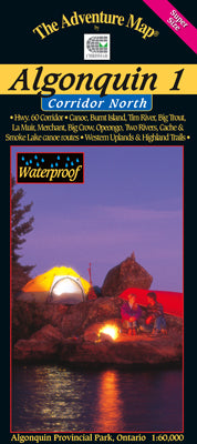
Algonquin 1 - Corridor North Map
ADVENTURE MAPSAll Maps are FINAL SALE Scale: 1:60,000. Waterproof. Our detailed topographic map & guide to all paddling routes, hiking & backpacking trai...
View full details
Original price
$16.99
-
Original price
$16.99
Original price
$16.99
$16.99
-
$16.99
Current price
$16.99
Original price
$16.99
-
Original price
$16.99
Original price
$16.99
$16.99
-
$16.99
Current price
$16.99
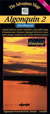
Algonquin 2 - Northwest Map
ADVENTURE MAPSAll maps are FINAL SALE Scale: 1:60,000. Waterproof. Our detailed topographic map & guide to the more remote northwest quadrant of Algonquin Pr...
View full details
Original price
$16.99
-
Original price
$16.99
Original price
$16.99
$16.99
-
$16.99
Current price
$16.99

Original price
$16.99
-
Original price
$16.99
Original price
$16.99
$16.99
-
$16.99
Current price
$16.99
Algonquin 3 - Corridor South Map
ADVENTURE MAPSALL MAPS FINAL SALE - Our detailed topographic map & guide to all paddling routes, hiking & backpacking trails, and attractions all along a...
View full details
Original price
$16.99
-
Original price
$16.99
Original price
$16.99
$16.99
-
$16.99
Current price
$16.99
Original price
$16.99
-
Original price
$16.99
Original price
$16.99
$16.99
-
$16.99
Current price
$16.99
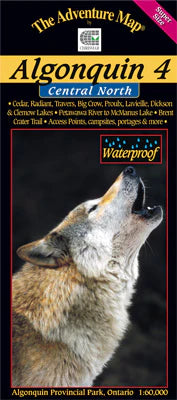
Algonquin 4 - North Central/Petawawa River Map
ADVENTURE MAPSALL MAPS/GUIDES ARE FINAL SALE The fourth in our main Algonquin series, this map covers the area from beyond the park boundary in the north all the...
View full details
Original price
$16.99
-
Original price
$16.99
Original price
$16.99
$16.99
-
$16.99
Current price
$16.99

Original price
$8.99
-
Original price
$8.99
Original price
$8.99
$8.99
-
$8.99
Current price
$8.99
Awenda Provincial Park Map
ADVENTURE MAPSALL MAPS/GUIDES ARE FINAL SALE Located on a broad point of land jutting north into Georgian Bay, Awenda is well-known for great hiking, exceptional...
View full details
Original price
$8.99
-
Original price
$8.99
Original price
$8.99
$8.99
-
$8.99
Current price
$8.99

Original price
$12.99
-
Original price
$12.99
Original price
$12.99
$12.99
-
$12.99
Current price
$12.99
Bon Echo Provincial Park & Area Map
ADVENTURE MAPSALL MAPS/GUIDES ARE FINAL SALE One of eastern Ontario's major provincial parks, this perennial favourite has something for everyone, including five...
View full details
Original price
$12.99
-
Original price
$12.99
Original price
$12.99
$12.99
-
$12.99
Current price
$12.99
Original price
$9.99
-
Original price
$9.99
Original price
$9.99
$9.99
-
$9.99
Current price
$9.99
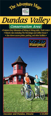
Dundas Valley Conservation Area Map
ADVENTURE MAPSALL MAPS FINAL SALE - A wilderness conservation area between the towns of Ancaster and Dundas, this area is popular with hikers, mountain bikers, a...
View full details
Original price
$9.99
-
Original price
$9.99
Original price
$9.99
$9.99
-
$9.99
Current price
$9.99

Original price
$13.99
-
Original price
$13.99
Original price
$13.99
$13.99
-
$13.99
Current price
$13.99
Franklin, Mink & McCoy Islands - Georgian Bay Map
ADVENTURE MAPSALL MAPS FINAL SALE - This is one of the most easily accessible, most popular sea kayaking area in all of the Great Lakes. And with thousands of is...
View full details
Original price
$13.99
-
Original price
$13.99
Original price
$13.99
$13.99
-
$13.99
Current price
$13.99

Original price
$13.99
-
Original price
$13.99
Original price
$13.99
$13.99
-
$13.99
Current price
$13.99
Frost Centre Area - Haliburton Highlands Map
ADVENTURE MAPSALL MAPS ARE FINAL SALE This popular map showcases over 500 km2 of wilderness in the Haliburton Highlands region of Ontario, including the popular ...
View full details
Original price
$13.99
-
Original price
$13.99
Original price
$13.99
$13.99
-
$13.99
Current price
$13.99

Original price
$8.99
-
Original price
$8.99
Original price
$8.99
$8.99
-
$8.99
Current price
$8.99
Grundy Lake Provincial Park & Area Map
ADVENTURE MAPSALL MAPS/GUIDES ARE FINAL SALE This 3636-hectare Provincial Park is one of only a few that prohibit motor boats so you'll be assured of an ...
View full details
Original price
$8.99
-
Original price
$8.99
Original price
$8.99
$8.99
-
$8.99
Current price
$8.99

Original price
$8.99
-
Original price
$8.99
Original price
$8.99
$8.99
-
$8.99
Current price
$8.99
Halfway Lake Provincial Park Map
ADVENTURE MAPSALL MAPS ARE FINAL SALE This compact but feature-rich provincial park sits on the Canadian Shield about an hour north of Sudbury. Easily accessibl...
View full details
Original price
$8.99
-
Original price
$8.99
Original price
$8.99
$8.99
-
$8.99
Current price
$8.99

Original price
$3.10
-
Original price
$3.10
Original price
$3.10
$3.10
-
$3.10
Current price
$3.10
Hiker Sign, Small, Algonquin, Blue
ADVENTURE MAPSThese low-cost diamond-shaped signs can mark a trail or help users differentiate between a hiking trail and a portage where they meet or cross. Sim...
View full details
Original price
$3.10
-
Original price
$3.10
Original price
$3.10
$3.10
-
$3.10
Current price
$3.10
Original price
$12.99
-
Original price
$12.99
Original price
$12.99
$12.99
-
$12.99
Current price
$12.99
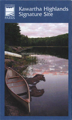
Kawartha Highlands Provincial Park Planning Map
ADVENTURE MAPSALL MAPS FINAL SALE - A medium-scale (1:40,000) paper map of Kawartha Highlands Provincial Park that can be helpful when planning your trip. It sho...
View full details
Original price
$12.99
-
Original price
$12.99
Original price
$12.99
$12.99
-
$12.99
Current price
$12.99

Original price
$18.99
-
Original price
$18.99
Original price
$18.99
$18.99
-
$18.99
Current price
$18.99
Killarney Provincial Park Planning Map WATERPROOF
ADVENTURE MAPSALL MAPS FINAL SALE This waterproof, large format, medium-scale (1:55,000) topographic map of the entirety of Killarney Provincial Park, is perfect...
View full details
Original price
$18.99
-
Original price
$18.99
Original price
$18.99
$18.99
-
$18.99
Current price
$18.99
Original price
$16.99
-
Original price
$16.99
Original price
$16.99
$16.99
-
$16.99
Current price
$16.99
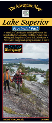
Lake Superior Provincial Park Map
ADVENTURE MAPSALL MAPS FINAL SALE - The eastern Lake Superior coast offers wonderfully rugged wilderness hiking and backpacking as well as coastline and backcoun...
View full details
Original price
$16.99
-
Original price
$16.99
Original price
$16.99
$16.99
-
$16.99
Current price
$16.99
Original price
$13.99
-
Original price
$13.99
Original price
$13.99
$13.99
-
$13.99
Current price
$13.99
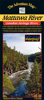
Mattawa River Provincial Park & Area Map
ADVENTURE MAPSALL MAPS FINAL SALE - The Mattawa River is one of Canada's most historic rivers. Stretching between the modern city of North Bay on Lake Nipissing ...
View full details
Original price
$13.99
-
Original price
$13.99
Original price
$13.99
$13.99
-
$13.99
Current price
$13.99
Original price
$16.99
-
Original price
$16.99
Original price
$16.99
$16.99
-
$16.99
Current price
$16.99
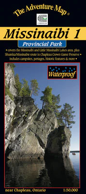
Missinaibi 1 - Lakes Area Map
ADVENTURE MAPSALL MAPS FINAL SALE - Most serious paddlers have heard of the Missinaibi River - the longest unbroken stretch of paddling river in Ontario ...
View full details
Original price
$16.99
-
Original price
$16.99
Original price
$16.99
$16.99
-
$16.99
Current price
$16.99
Original price
$16.99
-
Original price
$16.99
Original price
$16.99
$16.99
-
$16.99
Current price
$16.99
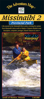
Missinaibi 2 - Missinaibi Lake to Mattice Map
ADVENTURE MAPSALL MAPS FINAL SALE - Most serious paddlers have heard of the Missinaibi River - the longest unbroken stretch of paddling river in Ontario - but th...
View full details
Original price
$16.99
-
Original price
$16.99
Original price
$16.99
$16.99
-
$16.99
Current price
$16.99
Original price
$16.99
-
Original price
$16.99
Original price
$16.99
$16.99
-
$16.99
Current price
$16.99
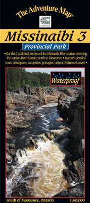
Missinaibi 3 - Mattice to Moosonee Map
ADVENTURE MAPSALL MAPS FINAL SALE - This 3rd guide in our Missinabi series covers the route from the Town of Mattice all the way downstream or northward to Mooso...
View full details
Original price
$16.99
-
Original price
$16.99
Original price
$16.99
$16.99
-
$16.99
Current price
$16.99

Original price
$14.99
-
Original price
$14.99
Original price
$14.99
$14.99
-
$14.99
Current price
$14.99
Mississagi Provincial Park & Area Map
ADVENTURE MAPSALL MAPS ARE FINAL SALE Our guide to this superb hiking and paddling area just north of Elliot Lake, Ontario, includes not only Mississagi P.P., bu...
View full details
Original price
$14.99
-
Original price
$14.99
Original price
$14.99
$14.99
-
$14.99
Current price
$14.99

Original price
$16.99
-
Original price
$16.99
Original price
$16.99
$16.99
-
$16.99
Current price
$16.99
Mississaugi River & Aubrey Fall Provincial Park Map
ADVENTURE MAPSALL MAPS ARE FINAL SALE This is one of Ontario's lesser-known, and used, wilderness paddling rivers. That's a little odd given that the 191-km-long...
View full details
Original price
$16.99
-
Original price
$16.99
Original price
$16.99
$16.99
-
$16.99
Current price
$16.99